Property Record
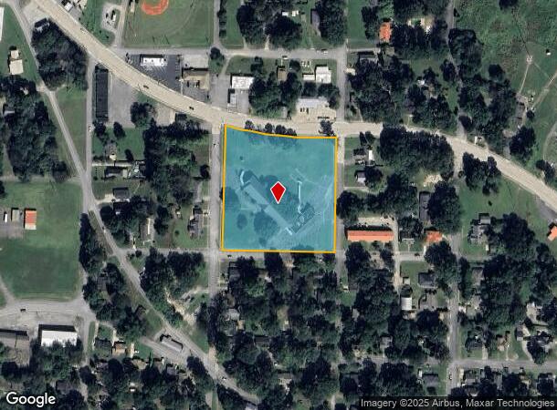
120 Gordon St, Rockmart, GA 30153

Property Detail
120 Gordon St
R09-063
6.50/Sf
Publicschool
21ST DISTRICT THIRD SECTION
X
Polk
13233C0093E
Georgia
0
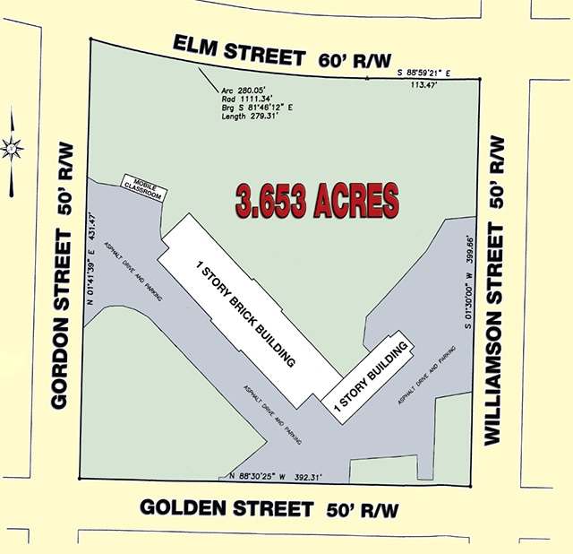
4.04 AC
2025
Georgia Northwest
010600
Other Market Areas
15,600 SF
Cedartown, GA
NEARBY LISTINGS FOR SALE OR LEASE
DEMOGRAPHICS near 120 Gordon St
1 mile
3 mile
5 mile
2024 Total Population
2,976
11,298
16,054
2029 Population
3,130
11,929
16,987
Pop Growth 2024-2029
+ 5.17%
+ 5.59%
+ 5.81%
Average Age
39
40
40
2024 Total Households
1,159
4,340
6,103
HH Growth 2024-2029
+ 5.00%
+ 5.46%
+ 5.67%
Median Household Inc
$48,891
$47,424
$49,601
Avg Household Size
2.50
2.60
2.60
2024 Avg HH Vehicles
2.00
2.00
2.00
Median Home Value
$134,639
$149,411
$157,638
Median Year Built
1976
1983
1986
Nearby Places
Map Layers
Map Styles
 Street
 Aerial
Transit
 Traffic
 Biking
Places
Listings with unknown addresses are not visible on the map
- Restaurants
- Banks
- Shops
- Fitness
- Groceries
Nearby Properties
Address
Land Use
TOTAL SIZE
Lot Size
Zoning
Address
Land Use
TOTAL SIZE
Lot Size
Zoning
417,231 SF
43.43 AC
Address
Land Use
TOTAL SIZE
Lot Size
Zoning
27,750 SF
60.84 AC
Address
Land Use
TOTAL SIZE
Lot Size
Zoning
306,003 SF
19.69 AC
Address
Land Use
TOTAL SIZE
Lot Size
Zoning
9,153 SF
10.17 AC
Address
Land Use
TOTAL SIZE
Lot Size
Zoning
30,012 SF
91.47 AC
Address
Land Use
TOTAL SIZE
Lot Size
Zoning
22,500 SF
26.86 AC
Address
Land Use
TOTAL SIZE
Lot Size
Zoning
158,416 SF
21.64 AC
Address
Land Use
TOTAL SIZE
Lot Size
Zoning
147,168 SF
9.29 AC
Address
Land Use
TOTAL SIZE
Lot Size
Zoning
217,500 SF
28.19 AC
Address
Land Use
TOTAL SIZE
Lot Size
Zoning
99,378 SF
11.99 AC
Address
Land Use
TOTAL SIZE
Lot Size
Zoning
17,002 SF
7.72 AC
Address
Land Use
TOTAL SIZE
Lot Size
Zoning
Address
Land Use
TOTAL SIZE
Lot Size
Zoning
14,116 SF
8.12 AC
Address
Land Use
TOTAL SIZE
Lot Size
Zoning
55,115 SF
18 AC
Address
Land Use
TOTAL SIZE
Lot Size
Zoning
68,902 SF
8.85 AC
Address
Land Use
TOTAL SIZE
Lot Size
Zoning
2,304 SF
85.86 AC
Address
Land Use
TOTAL SIZE
Lot Size
Zoning
1,068 SF
7.41 AC
Address
Land Use
TOTAL SIZE
Lot Size
Zoning
44,653 SF
8.18 AC
Address
Land Use
TOTAL SIZE
Lot Size
Zoning
15.88 AC
Address
Land Use
TOTAL SIZE
Lot Size
Zoning
10,425 SF
16.50 AC
Address
Land Use
TOTAL SIZE
Lot Size
Zoning
14,032 SF
5.16 AC
Address
Land Use
TOTAL SIZE
Lot Size
Zoning
19,544 SF
12.56 AC
Address
Land Use
TOTAL SIZE
Lot Size
Zoning
22,300 SF
4.33 AC
Address
Land Use
TOTAL SIZE
Lot Size
Zoning
133,395 SF
9.53 AC
Address
Land Use
TOTAL SIZE
Lot Size
Zoning
1,200 SF
3.43 AC
Address
Land Use
TOTAL SIZE
Lot Size
Zoning
18,116 SF
1 AC
Address
Land Use
TOTAL SIZE
Lot Size
Zoning
13,476 SF
63 AC
Address
Land Use
TOTAL SIZE
Lot Size
Zoning
4,978 SF
1.70 AC
Address
Land Use
TOTAL SIZE
Lot Size
Zoning
40,378 SF
1.34 AC
Address
Land Use
TOTAL SIZE
Lot Size
Zoning
6,043 SF
1.67 AC
The World's #1 Commercial Real Estate Marketplace
Connect with us
© 2026 CoStar Group
The information above has been obtained from sources believed reliable. While we do not doubt its accuracy we have not verified it and make no guarantee, warranty or representation about it. It is your responsibility to independently confirm its accuracy and completeness. Any projections, opinions, assumptions, or estimates used are for example only and do not represent the current or future performance of the property. The value of this transaction to you depends on tax and other factors which should be evaluated by your tax, financial, and legal advisors. You and your advisors should conduct a careful, independent investigation of the property to determine to your satisfaction the suitability of the property for your needs.